A ten km contour interval? Well yes, if you are mapping the thickness of the earth's crust!
This map brings out beautifully the distribution of the two distinct types of crust on earth. Crust making up the continents is granitic to andesitic in composition, buoyant and is old. Crust making up the ocean basins is mafic in composition, gravitationally unstable (it is heavier and it subducts) and is young.
The 30 km contour outlines roughly the continental crust:

I got this from - The Continental Record and the Generation of Continental Crust (open access)
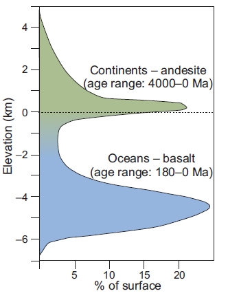
How does the earth look in terms of its topography? There is a bimodal distribution of the surface elevations on earth. This is a consequence of the contrasting chemical-mechanical properties of the continental and oceanic crust. The figure below brings out the distribution.
Why is there some continent below sea level? Plate tectonic configuration can be such that at different coastlines continents could be in the act of converging with an oceanic plate. Or, having long broken away from another continent, they posses a passive or divergent margin. At such passive margins, continental crust does not end at the present day coastline, but extends further out until the edge of the continental shelf where there is a sudden deepening of the sea floor. That is roughly where the ancient continent broke up. As it drifted away, new oceanic crust formed between its conjugate continent on the opposite side. Sea level rise after the last glaciation has flooded continents, thereby submerging portions of these passive margin low gradient shelves.

Source: The Continental Record and the Generation of Continental Crust.
Sometimes, a single map or a graph can bring out a fundamental truth about the making of the earth.
This map brings out beautifully the distribution of the two distinct types of crust on earth. Crust making up the continents is granitic to andesitic in composition, buoyant and is old. Crust making up the ocean basins is mafic in composition, gravitationally unstable (it is heavier and it subducts) and is young.
The 30 km contour outlines roughly the continental crust:
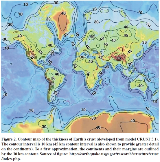
I got this from - The Continental Record and the Generation of Continental Crust (open access)
How does the earth look in terms of its topography? There is a bimodal distribution of the surface elevations on earth. This is a consequence of the contrasting chemical-mechanical properties of the continental and oceanic crust. The figure below brings out the distribution.
Why is there some continent below sea level? Plate tectonic configuration can be such that at different coastlines continents could be in the act of converging with an oceanic plate. Or, having long broken away from another continent, they posses a passive or divergent margin. At such passive margins, continental crust does not end at the present day coastline, but extends further out until the edge of the continental shelf where there is a sudden deepening of the sea floor. That is roughly where the ancient continent broke up. As it drifted away, new oceanic crust formed between its conjugate continent on the opposite side. Sea level rise after the last glaciation has flooded continents, thereby submerging portions of these passive margin low gradient shelves.
Source: The Continental Record and the Generation of Continental Crust.
Sometimes, a single map or a graph can bring out a fundamental truth about the making of the earth.