
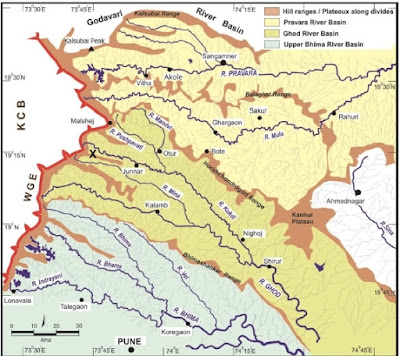
Last Sunday I visited Chavand fort near the town of Junnar, about 110 km north of Pune. This is a rugged terrain marked by several NW-SE oriented ridges separated by broad U shaped valleys. In the map below the black cross marks the location of Chavand. WGE refers to the Western Ghat Escarpment and KCB refers to the Konkan Coastal Belt. Trekkers familiar with this region will recognize the hill ranges, especially the Bhimashankar range and the Harishchandragad range. And near the town of Junnar is Shivneri fort, birthplace of the Maratha king Shivaji.
Source: Kale et. al, 2016
When Deccan volcanism ended, this region would have been a vast flat- to- gently undulating lava surface. At that time, some 60 million years ago, you could have walked from where Bhimashankar temple now stands to the present location of Harishchandragad along broadly the same elevation without the need to climb down several hundred feet or so into a valley and then climb up again. Over time however, south easterly flowing rivers and tributaries have gouged out grooves within this large plateau, dissecting it into a valley and ridge terrain.
The geomorphology of this region therefore reflects the creation of relief due to removal of material by erosion. This contrasts with other areas like the famous Basin and Range Province in western United States, where parallel faults have moved blocks of crust hundreds of feet to form a system of flat bottomed valleys (grabens) and flat topped ridges (horsts).
The Western Uplands end abruptly along the Western Ghat Escarpment, a sinuous west facing cliff overlooking the Konkan coastal plain. The escarpment is the edge of the Deccan Plateau.
There is another factor that has shaped this landscape. Take a look below at a satellite imagery of this area. The arrows mark fracture systems that have broken this plateau.

Erosion along these zones of weakened rock results in slabs of basalts peeling on rock faces. Over time, the result is a landscape that fragments into mesas, buttes and pinnacles. Chavand is one such mesa. Notice its straight edged polygonal shape suggestive of erosion along fracture planes.
Many of these fracture systems originated in the tensional forces that the western margin of India experienced during rifting and associated Deccan volcanism. After its separation from Madagascar around 88 million years ago, the Indian continent's rifted and the fractured western margin migrated over the Reunion hotspot, an unusually hot area of the mantle. The result, beginning around 68 million years ago was Deccan volcanism. Some of these linear structures, common in the area around Sangamner, are dikes. They are the pipes which brought up magma from deep subsurface chambers to the surface. Continued rifting of the western margin resulted ultimately in crustal blocks subsiding along a series of N-S oriented parallel faults. The Western Ghat Escarpment likely originated as a west facing fault scarp, but it would have been located as much as a 100 km to the west of its present location. Erosion over million of years has resulted in an eastward retreat of this feature to where it stands now.
Picture below shows how hill ranges have been broken by a fracture system, resulting in isolated pinnacles.

And here is a picture of Chavand.

Recently my friend Vivek Kale and colleagues complied some very interesting geomorphologic, structural and sedimentology data to suggest that these western uplands have experience some tectonic movements during Quaternary times (past 2.58 million years). They emphasize that the Deccan plateau and Western Upland should not be regarded as a monolithic stable crust block. They point to three major fracture systems (F1, F5, F7 in the map below) which have segmented this part of the western upland. The central segment, i.e. the area north of Chavand, roughly between fracture systems F1 and F5 has moved up relative to the blocks to the north and south. The presence of sediments deposited in the Pravara river system and along F1 and some streams to the south is evidence that the these blocks subsided somewhat, resulting in stretches of streams becoming sediment traps.

Source: Adapted in Kale et. al 2016 from Dole et.al. 2000, Dole et. al. 2002, Bondre et.al. 2006
These sediments represent deposition over the past 100,000 years or so. At some localities along the Mahalungi river, they have been deformed. Soft sediment deformation structures such as slumping, load structures and sand dykes have been recorded by Dole and colleagues. Such structures are evidence of ground shaking and sediment liquefaction and remobilization during earthquakes. Also observed at one locality is reverse faulting. The faulting has been inferred to be of Holocene age, as recent as the past 10,000 years.
These structural movements have also disrupted and modified the antecedent drainage of this region. The map above shows several easterly flowing streams (R. Mahaludi, R. Adula, R. Mula, R. Madvi, R. Pushavati) in this region abruptly turning southeast as they intersect NW-SE trending fractures. The yellow overlay on the map indicates sedimentary deposits. The major fracture systems F1, F5, F7 likely reflect faults in the Precambrian continental crust underlying the Deccan volcanics. They have been rejuvenated in Quaternary times and have cut across and caused dislocations of the volcanic pile.
There are other interesting drainage features in this region. Many streams have stretches with potholes (Nighoj on R. Kukdi), cascades (stretches of R. Pushpavati, R. Mula, R. Ghod, R. Bhama) and entrenched meandering channels (R. Pravara, R. Mula, R. Ghod, R. Vel) all suggesting episodes of increased vigor of stream down cutting. Whether this is a climatic signal (e.g. increase in rainfall will increase water flow and stream erosive power) or is tectonically triggered (e.g. slight uplift and tilting of land will increase stream gradient, resulting in more vigorous stream flow and down cutting), as Kale and colleagues have recently argued, is an active area of research.
 Finally, the giant plagioclase basalts. Plagioclase, which belongs to the feldspar family of minerals, is a major component of basalts. The entire Deccan volcanic lava sequence is subdivided into three subgroups based on geochemical differences. The giant plagioclase basalt lava flows occur predominantly in the lower part of the volcanic sequence. The table on the left (Kale et. al. 2016) shows the geochemical stratigraphy of the Deccan volcanic sequence with the location of the giant plagioclase basalts (GPB). The GPB flows cap individual formations within the Kalsubai Subgroup. This has been interpreted by many geologists to mean that they mark the final eruptions of a magmatic cycle. Because of their distinctive appearance these GPB flows have proved to be useful as marker horizons in stratrigraphic mapping.
The plagioclase crystals are greater than 1 cm and often have grown to several centimeters long. They are surrounded by a fine grained to glassy matrix. The picture below is a close up of a giant plagioclase basalt, showing tabular plagioclase phenocrysts (arrows).

Geologists agree that these giant crystals grew slowly in magma chambers tens of kilometers deep in the subsurface. These crystals were then brought to the surface by ascending magma, which then cooled rapidly on the surface forming a fine grained to glassy matrix. This two stage crystallization history is the reason for the two distinct grain sizes in this rock.
The picture below shows Chavand fort hill face. The giant plagioclase basalt lava flow makes up the shrubby gentler slope. These basalts are vesicular (containing pits and holes due to trapped gas bubbles in the lava) and softer and have weathered to form the gentler slopes. The upper harder and more compact basalt forms cliffs.

There are differing views however on how long these crystals were growing in the subsurface and what that implies for the mode and duration of Deccan eruptions. I"ll leave the details for another post. Meanwhile, here is another picture of the giant plagioclase basalt showing lath shaped plagioclase grains (1) and a rosette of plagioclase phenocrysts (2).

...And a few more pictures of the terrain as seen from the top of Chavand.
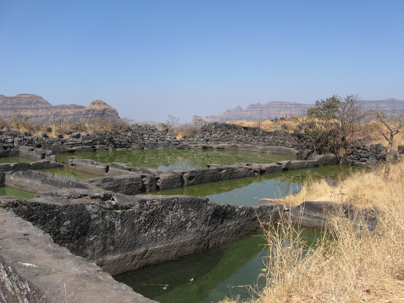
A large water tank dug out from the hard basalt

Mesa top grasslands give way to the rugged ranges of the Western Uplands. This is a north facing view with the Harishchandra range at the far end.

A south facing view with the Bhimashankar range with its forested plateaus.

..did I mention it was a pretty steep climb?

Until next time...

Source: Kale et. al, 2016
When Deccan volcanism ended, this region would have been a vast flat- to- gently undulating lava surface. At that time, some 60 million years ago, you could have walked from where Bhimashankar temple now stands to the present location of Harishchandragad along broadly the same elevation without the need to climb down several hundred feet or so into a valley and then climb up again. Over time however, south easterly flowing rivers and tributaries have gouged out grooves within this large plateau, dissecting it into a valley and ridge terrain.
The geomorphology of this region therefore reflects the creation of relief due to removal of material by erosion. This contrasts with other areas like the famous Basin and Range Province in western United States, where parallel faults have moved blocks of crust hundreds of feet to form a system of flat bottomed valleys (grabens) and flat topped ridges (horsts).
The Western Uplands end abruptly along the Western Ghat Escarpment, a sinuous west facing cliff overlooking the Konkan coastal plain. The escarpment is the edge of the Deccan Plateau.
There is another factor that has shaped this landscape. Take a look below at a satellite imagery of this area. The arrows mark fracture systems that have broken this plateau.

Erosion along these zones of weakened rock results in slabs of basalts peeling on rock faces. Over time, the result is a landscape that fragments into mesas, buttes and pinnacles. Chavand is one such mesa. Notice its straight edged polygonal shape suggestive of erosion along fracture planes.
Many of these fracture systems originated in the tensional forces that the western margin of India experienced during rifting and associated Deccan volcanism. After its separation from Madagascar around 88 million years ago, the Indian continent's rifted and the fractured western margin migrated over the Reunion hotspot, an unusually hot area of the mantle. The result, beginning around 68 million years ago was Deccan volcanism. Some of these linear structures, common in the area around Sangamner, are dikes. They are the pipes which brought up magma from deep subsurface chambers to the surface. Continued rifting of the western margin resulted ultimately in crustal blocks subsiding along a series of N-S oriented parallel faults. The Western Ghat Escarpment likely originated as a west facing fault scarp, but it would have been located as much as a 100 km to the west of its present location. Erosion over million of years has resulted in an eastward retreat of this feature to where it stands now.
Picture below shows how hill ranges have been broken by a fracture system, resulting in isolated pinnacles.

And here is a picture of Chavand.

Recently my friend Vivek Kale and colleagues complied some very interesting geomorphologic, structural and sedimentology data to suggest that these western uplands have experience some tectonic movements during Quaternary times (past 2.58 million years). They emphasize that the Deccan plateau and Western Upland should not be regarded as a monolithic stable crust block. They point to three major fracture systems (F1, F5, F7 in the map below) which have segmented this part of the western upland. The central segment, i.e. the area north of Chavand, roughly between fracture systems F1 and F5 has moved up relative to the blocks to the north and south. The presence of sediments deposited in the Pravara river system and along F1 and some streams to the south is evidence that the these blocks subsided somewhat, resulting in stretches of streams becoming sediment traps.

Source: Adapted in Kale et. al 2016 from Dole et.al. 2000, Dole et. al. 2002, Bondre et.al. 2006
These sediments represent deposition over the past 100,000 years or so. At some localities along the Mahalungi river, they have been deformed. Soft sediment deformation structures such as slumping, load structures and sand dykes have been recorded by Dole and colleagues. Such structures are evidence of ground shaking and sediment liquefaction and remobilization during earthquakes. Also observed at one locality is reverse faulting. The faulting has been inferred to be of Holocene age, as recent as the past 10,000 years.
These structural movements have also disrupted and modified the antecedent drainage of this region. The map above shows several easterly flowing streams (R. Mahaludi, R. Adula, R. Mula, R. Madvi, R. Pushavati) in this region abruptly turning southeast as they intersect NW-SE trending fractures. The yellow overlay on the map indicates sedimentary deposits. The major fracture systems F1, F5, F7 likely reflect faults in the Precambrian continental crust underlying the Deccan volcanics. They have been rejuvenated in Quaternary times and have cut across and caused dislocations of the volcanic pile.
There are other interesting drainage features in this region. Many streams have stretches with potholes (Nighoj on R. Kukdi), cascades (stretches of R. Pushpavati, R. Mula, R. Ghod, R. Bhama) and entrenched meandering channels (R. Pravara, R. Mula, R. Ghod, R. Vel) all suggesting episodes of increased vigor of stream down cutting. Whether this is a climatic signal (e.g. increase in rainfall will increase water flow and stream erosive power) or is tectonically triggered (e.g. slight uplift and tilting of land will increase stream gradient, resulting in more vigorous stream flow and down cutting), as Kale and colleagues have recently argued, is an active area of research.

The plagioclase crystals are greater than 1 cm and often have grown to several centimeters long. They are surrounded by a fine grained to glassy matrix. The picture below is a close up of a giant plagioclase basalt, showing tabular plagioclase phenocrysts (arrows).

Geologists agree that these giant crystals grew slowly in magma chambers tens of kilometers deep in the subsurface. These crystals were then brought to the surface by ascending magma, which then cooled rapidly on the surface forming a fine grained to glassy matrix. This two stage crystallization history is the reason for the two distinct grain sizes in this rock.
The picture below shows Chavand fort hill face. The giant plagioclase basalt lava flow makes up the shrubby gentler slope. These basalts are vesicular (containing pits and holes due to trapped gas bubbles in the lava) and softer and have weathered to form the gentler slopes. The upper harder and more compact basalt forms cliffs.

There are differing views however on how long these crystals were growing in the subsurface and what that implies for the mode and duration of Deccan eruptions. I"ll leave the details for another post. Meanwhile, here is another picture of the giant plagioclase basalt showing lath shaped plagioclase grains (1) and a rosette of plagioclase phenocrysts (2).

...And a few more pictures of the terrain as seen from the top of Chavand.
A large water tank dug out from the hard basalt
Mesa top grasslands give way to the rugged ranges of the Western Uplands. This is a north facing view with the Harishchandra range at the far end.

A south facing view with the Bhimashankar range with its forested plateaus.

..did I mention it was a pretty steep climb?

Until next time...


