Remotely India # 9 (a post series about landforms and geological structures imaged by remote sensing satellites).
This is a geology rich image!

Source: Rajasthan Tourism
It shows Gagron Fort in the Jhalawar district of Rajasthan. I came across it while watching a history show on EPIC channel. Looking at the steeply dipping strata I identified them as the metamorphosed and deformed Aravalli Group sediments of early Proterozoic age.
I then checked a geological map and realized I had gotten the stratigraphy completely wrong. These steeply dipping rocks belong to the mid-late Proterozoic Vindhyan Group of sediments.
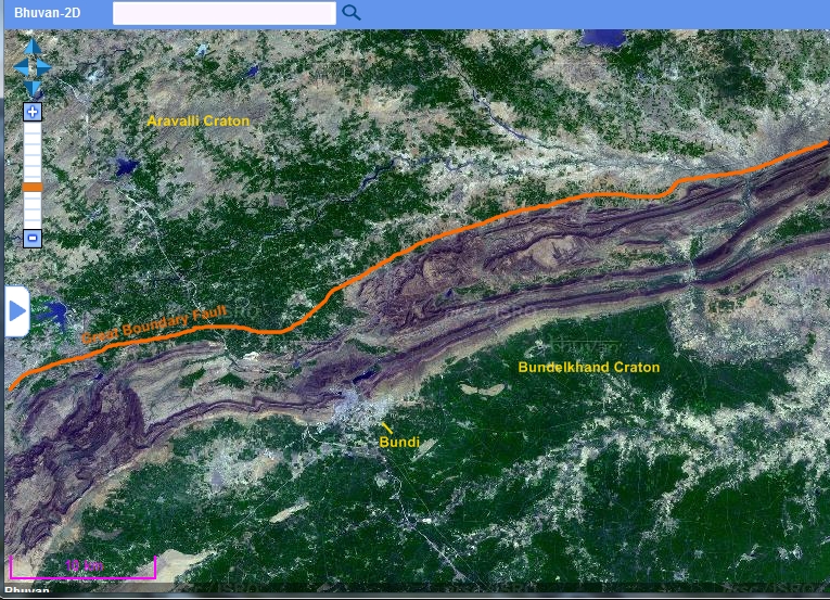
There are two distinct categories of Proterozoic basins in India. There are the mobile belts. An example of a mobile belt is the Aravalli orogenic belt. As the name suggests, these basins formed as linear depressions at the margins of Archaean cratonic blocks. They are filled with volcano-sedimentary successions, intruded by granitic bodies and subjected to intense deformation and metamorphism during convergence and collision between different cratonic blocks. They are economically important. Lead, zinc, copper, iron ore is mined from various mobile belts. The Aravalli belt formed due to the collision between the Aravalli craton and the Bundelkhand craton. Sedimentation in the Aravalli basin was initiated around 2 billion years ago. Their deformation and metamorphism has been dated to around 1.7-1.6 billion years ago.
The second category of basins are the epicratonic basins, developed as either rift basins or foreland basins within cratonic blocks. Volcanic activity is mostly restricted to the early stages of basin evolution. Sedimentary successions are sandstones, shale and limestone. Collectively these are known as the 'Purana' (ancient) basins. They show very light to no metamorphism and relatively gentle deformation. Flat lying strata form mesas and plateaus in the interior of such basins. The degree of deformation usually increase at the basin margins. In proximity to basin margins faults, sediments are often spectacularly folded. The Vindhyan Basin is a 'Purana' style basin.
I am putting up a few examples of folding in Vindhyan Basin sediments. These range in age from about 1.7 billion to 650 million years.
The first one is the Jhalawar anticline in proximity to the Mukundara Fault. Fort Gagron was built on the steep NE dipping limb made up of the Kaimur sandstones.

Mukundara Fault is an easterly directed thrust fault. See this cross section across the Jhalawar anticline.

Source: Rajeev Bhoj, Avdhesh Nautiyal and Rajesh Sharma 2011: Regional Structural Style of Chambal Valley Vindhyan Basin, Rajasthan, India
This second example of folding is south and east of the famous fort at Chittorgarh. Lower Vindhyan Group sediments have been folded into N-S trending tight anticlines and synclines.

This folded zone abuts the Great Boundary Fault which structurally juxtaposes the Bundelkhand Craton with the Aravalli Craton. The fault brings into contact the Aravalli mobile belt and the Vindhyan 'Purana' basin. The Great Boundary Fault is a NW dipping thrust fault (ref).
Finally, northeast of the previous location, also along the Great Boundary Fault in the vicinity of the town of Bundi are these folded Upper Vindhyan sediments. These are the sandstones and limestones of the Rewa and Bhander Group.

And below is a geological map of the region to give some context to these structures. The Great Boundary Fault and the Mukundara Fault are orthogonal to each other, testimony to differently oriented compressive forces affecting the Vindhyan Basin.

Source: Rajeev Bhoj, Avdhesh Nautiyal and Rajesh Sharma 2011: Regional Structural Style of Chambal Valley Vindhyan Basin, Rajasthan, India
Three distinct structural trends can be seen in this part of the Vindhyan Basin. A NE-SW trend of the Great Boundary Fault. A N-S trend of the tight folds south and east of Chittorgarh. And a NW-SE trend of the Mukundara Fault and associated folds. The other major structural trend in the Vindhyan Basin is the E-W trend of Narmada rift fault zone which forms the southern boundary of the basin.
All satellite images from the Indian Remote Sensing satellite Cartosat series, accessible through ISRO's web mapping application Bhuvan.
This is a geology rich image!

Source: Rajasthan Tourism
It shows Gagron Fort in the Jhalawar district of Rajasthan. I came across it while watching a history show on EPIC channel. Looking at the steeply dipping strata I identified them as the metamorphosed and deformed Aravalli Group sediments of early Proterozoic age.
I then checked a geological map and realized I had gotten the stratigraphy completely wrong. These steeply dipping rocks belong to the mid-late Proterozoic Vindhyan Group of sediments.
There are two distinct categories of Proterozoic basins in India. There are the mobile belts. An example of a mobile belt is the Aravalli orogenic belt. As the name suggests, these basins formed as linear depressions at the margins of Archaean cratonic blocks. They are filled with volcano-sedimentary successions, intruded by granitic bodies and subjected to intense deformation and metamorphism during convergence and collision between different cratonic blocks. They are economically important. Lead, zinc, copper, iron ore is mined from various mobile belts. The Aravalli belt formed due to the collision between the Aravalli craton and the Bundelkhand craton. Sedimentation in the Aravalli basin was initiated around 2 billion years ago. Their deformation and metamorphism has been dated to around 1.7-1.6 billion years ago.
The second category of basins are the epicratonic basins, developed as either rift basins or foreland basins within cratonic blocks. Volcanic activity is mostly restricted to the early stages of basin evolution. Sedimentary successions are sandstones, shale and limestone. Collectively these are known as the 'Purana' (ancient) basins. They show very light to no metamorphism and relatively gentle deformation. Flat lying strata form mesas and plateaus in the interior of such basins. The degree of deformation usually increase at the basin margins. In proximity to basin margins faults, sediments are often spectacularly folded. The Vindhyan Basin is a 'Purana' style basin.
I am putting up a few examples of folding in Vindhyan Basin sediments. These range in age from about 1.7 billion to 650 million years.
The first one is the Jhalawar anticline in proximity to the Mukundara Fault. Fort Gagron was built on the steep NE dipping limb made up of the Kaimur sandstones.

Mukundara Fault is an easterly directed thrust fault. See this cross section across the Jhalawar anticline.

Source: Rajeev Bhoj, Avdhesh Nautiyal and Rajesh Sharma 2011: Regional Structural Style of Chambal Valley Vindhyan Basin, Rajasthan, India
This second example of folding is south and east of the famous fort at Chittorgarh. Lower Vindhyan Group sediments have been folded into N-S trending tight anticlines and synclines.

This folded zone abuts the Great Boundary Fault which structurally juxtaposes the Bundelkhand Craton with the Aravalli Craton. The fault brings into contact the Aravalli mobile belt and the Vindhyan 'Purana' basin. The Great Boundary Fault is a NW dipping thrust fault (ref).
Finally, northeast of the previous location, also along the Great Boundary Fault in the vicinity of the town of Bundi are these folded Upper Vindhyan sediments. These are the sandstones and limestones of the Rewa and Bhander Group.
And below is a geological map of the region to give some context to these structures. The Great Boundary Fault and the Mukundara Fault are orthogonal to each other, testimony to differently oriented compressive forces affecting the Vindhyan Basin.

Source: Rajeev Bhoj, Avdhesh Nautiyal and Rajesh Sharma 2011: Regional Structural Style of Chambal Valley Vindhyan Basin, Rajasthan, India
Three distinct structural trends can be seen in this part of the Vindhyan Basin. A NE-SW trend of the Great Boundary Fault. A N-S trend of the tight folds south and east of Chittorgarh. And a NW-SE trend of the Mukundara Fault and associated folds. The other major structural trend in the Vindhyan Basin is the E-W trend of Narmada rift fault zone which forms the southern boundary of the basin.
All satellite images from the Indian Remote Sensing satellite Cartosat series, accessible through ISRO's web mapping application Bhuvan.